John Blake (seen originally as Black) was the original proprietor of this home lot. He deeded it to his son Samuel who settled there and was on the list to draw the 30 acre out lot, and for generations it was known as the Blake Homestead. He also sold some of the East Street frontage of lot 13 to Amos Morrill, including one which was later deeded to two of his sons, then to Jonathan Locke, and to Caleb Haynes. Caleb Haynes apparently built on the property as he sold out to James Marden and Thomas D. Merrill and finally to Jeremiah Prescott, who bought out Merrill and Marden. Prescott sold it to James and Samuel Weeks, being known for a long period of time as ‘the old Weeks place.’
Samuel Blake by will left the homestead to his son Samuel Blake, who sold the homestead to his sister Elizabeth, who married in 1797 John Chesley. The property remained in the family through his son John Chesley; his son Daniel Gilman Chesley; to his daughter Eleanora Chesley who married Lewis Nutter. She prepared a talk to the Epsom Historical Association in 1970, which gives a wonderful history of the homestead.
A meeting of the proprietors was held in 1743 but these meetings were not necessarily held in their township. The early settlers spent the warm months of the year on their Epsom acreage and returned to their former homes in Rye, Greenland or other towns for the winter.
In 1749 John Blake deeded to his son Samuel Lot #10 of the Home Lots. Samuel also owned Lot # 9 as a later deed for the property showed. {Actual lots 13 & 14} These two 50 acres lots were laid out in 1732. They were bounded on the north by that part of the Center road known as West Street, and extended in a southerly direction 160 rods up Sanborn Hill to land of Charles McCoy, an early settler. He sold his land in 1760 to Reuben and Eliphalet Sanborn and it has been in possession of the Sanborn family until recent years. This is how Sanborn Hill got its name. There was an early house on one of these lots on the Center Road at the corner of the old Sanborn Hill Road. This may have been the home of Samuel’s older brother John.
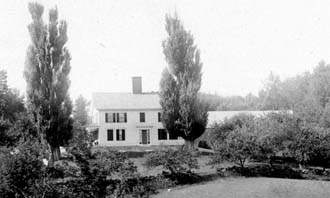
Samuel was married in 1743 and probably about that time built his house on the location where my present house stands.
He was a friend to the Indians and in fact paid them for the land he had already been granted. The price was ten shillings but for one of these shilling he gave them his knife which they had much admired. So the story had always been told that he bought his 100 acre farm from the Indians for 9 shillings and a jack-knife. He also invited the Indians into his house to partake of meat roasted in the fireplace, which pleased them very much. Once when he was searching for his wandering cow, one of his Indian friends warned him of the presence of Indians of an unfriendly tribe so that he was able to return home safely.
The first house was destroyed by fire. Evidence of the fire remained for many years as one of the young Lombardy poplars in front of the house was badly burned. These trees had been brought from England and lived to grow to great size, and were finally blown over by strong winds when about 150 years old. The fire burned one of them but it still grew with deep indentations in its trunk. In later years its girth going in and out of the indentations was 28 feet.The present house was built soon after the American Revolution, 1784. Its Colonial style is very similar to that of the one built on the Parsonage Lot on Center Hill about the same time, now the home of Mr. Hughes, also the Sanborn House, now the home of Dr. Clark.
The foundation of the house is of granite, the great blocks having been hauled from the quarries in Hooksett and Allenstown by ox teams. The house was built facing the Center Road with the end and side entrance facing the old Sanborn Hill road. The road we now use was built many years later, about 1847, as the town had grown in the direction of the village on the new turnpike road. This was shorter and avoided the steeper hills.
Lumber for the house was no doubt cut on the farm and sawed in the mill of which Samuel Blake was part owner. Supporting timbers were hand hewn. The large central chimney rests on a great pile of rocks in the middle of the cellar. Rocks were no problem to obtain as every hillside farm had them in abundance as is evidenced by the miles of stone walls all over the countryside, and the rock piles which were enlarged year after year by rocks picked up from the filed as they were prepared for cultivation. Another method of disposing of large rocks was to sink them by digging a hole at the side and tipping them over into it. Even so, many extra large rocks were left in the fields, which interfere greatly with present day machine work. To return to the chimney, it was built with five flues to serve five fireplaces, two of them in the front upstairs rooms. The one in the main room served as kitchen, dining room and living room is large enough to accommodate a 4-foot cordwood stick. It also has a brick oven and ash pit. There are 9 rooms in the main house with a large open chamber and full size attic. The present ell was added nearly 100 years later to replace a small summer kitchen. The rooms are large (15 by 16) to provide for the large families of those times. Samuel Blake had 19 children. The flooring is of wide boards. The boards in the main room are 20 feet long. All of the downstairs doors are of the Christian type except for one narrow cupboard. All doors had latches.
The upstairs rooms were not completely finished off until Civil War times when it was easy to obtain competent labor from skilled artisans, men working their way to Canada to escape the draft. It may have been at this time that the windows with small panes were replaced with four pane windows. Four of the original windows were left in the attic, two at each end.
Other changes to modernize the house have been the removal of corner posts in the east front room or parlor, changing of several latches to doorknobs, and papering over wide paneling. All of the fireplaces were bricked up. We have opened two of them and probably will open the others.Seven generations have enjoyed the privilege of living in this old house. If the walls could talk, what interesting stories they might tell!!
John Chesley sold another small lot next to the Week's home to William
Rand of Portsmouth. William Rand may have occupied the house at times
as he is seen paying poll tax 1846 to 1848, showing no buildings, but
some livestock. He does not pay tax from 1850 onward, but appears in 1860,
no poll and "in care of Uriah Hall" with buildings on three
acres. Uriah Hall lived on the next lot west. It is possible this William
Rand died in 1860, his sister Olive being the wife of Uriah Hall. The
family connection appears to continue as William or his heirs sell the
lot to Hall B. Rand, a brother, who sells to John D. Dow of Epsom. John
D. Dow sold the property just before he died to Elbridge G. Batchelder,
in whose family it remained until 1901. At this time it became the home
of James Van Bunker and his wife Sarah. She out lived her husband and
sold the land to Percy E. Hall in 1930.
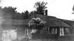
There is also another small lot, west of the Sarah Bunker lot for which early deeds are scarce or missing. The 1858 County Map shows the lot belonging to Uriah Hall, and included a coopers shop. Uriah Hall had married about 1825 Olive Rand, daughter of Tobias T. and Mary (Lear) Rand, who had brothers William and Hall B. involved in the adjoining lot. The home apparently passed to son Uriah G. Hall, son of Tobias, and is eventually sold to George W. Ham by 1864. This small lot passes through various heirs, through his widow, Myra L. (Yeaton) Ham who was married first to Stillman E. Sherburne. Among the heirs, Harry E. Sherburne and his sister, Grace Belle (Sherburne) Stone. Arthur Stone and his wife Grace B. (Sherburne) had one daughter Marion, who married Charles N. Huckins.
ROCKINGHAM COUNTY DEEDS HOME LOT #13
55-60 April 22, 1749
John Blake of Hampton, yeoman, by my son Samuel Blake of Epsom,
Land in Epsom containing by estimation 50 acres as it is laid out and
bounded,andis the home lot so called and original tenth lot in Number
and is bounded as follow: eastward upon Mr. Hains land and westwardly
upon Samuel Walles land, north upon the East street and southward upon
Charles McCoy. – John Blake [note: the lot number is actually 13,
and can be verified as Samuel Blake bought in 1742, bought the Hains lot
(14) which is east of this lot, as is the lot of Samuel being west (lot
12)].
Will of Samuel Blake (1797) leaves items to his wife Sarah, and one dollar to each of the daughters; the rest to son Samuel Blake, to pass then to son James in the event Samuel dies.
237-85 July 1, 1823
Samuel Blake of Epsom, yeoman to John Chesley of Epsom,
A parcel of land in Epsom and bounded as follows: on the south on land
owned by Josiah Sanborn and Ira Sanborn; on the east by land owned or
occupied by Jonathan Curtis Jr., being the parsonage lot (so called) on
the north by land owned by Thomas D. Merrill, Isaac Towle and Jeremiah
Prescott; and on the west by land owned by said Prescott and Josiah Sanborn.
The above part of lots numbered 9 and 10 of the home lots in said Epsom,
and all the homestead of the said Blake to contain 100 acres more or less.
– Samuel Blake [note: Blake uses inaccurate home lot #’s, as
these should be 13 and 14, one deed from John Blake to Samuel as 10 (13)
and the other Hains to Blake (14)]
MERRIMACK COUNTY DEEDS HOME LOT #13
(M) 266-48 February 17, 1883
John Chesley and Joanna Chesley of Epsom to Daniel G. and John A. Chesley,
All of our real estate in Epsom, consists of the following tracts of land:
the homestead farm of John and Joanna Chesley with buildings thereon bounded
on the north by the main road leading from Epsom Center to Deerfield the
land of Almira Ham, Mrs. Samuel Weeks, Charles J. Brown and John C. Hall,
on the east by land of John C. Hall, Hannah P. Steele and Charles H. Carpenter,
on the south by land of William T. Sanders and land of John Sanborn, and
on the west by land of John Sanborn and land of Andrew S. Evans. The Mountain
pasture (so called) conveyed to us by the said John Chesley and Joanna
Chesley by Jewett Eastman containing 40 acres, for further description
see deed recorded Merrimack County. The tract of land known as the Grant
place, see Merrimack County Lib 185-524. The Allen Place (so called) containing
20 acres, see Merrimack County 134-502. The Hall place (so called) with
buildings thereon, see Merrimack County Lib. 161 Vol. 257. The tract of
land known as the Goss lot containing 10 acres, Merrimack Records Lin.
204 Vol. 556. The tract of land known as the Morrill lot, see Merrimack
records Lib. 157, Vol. 141. The tract of land known as the Tarleton Lot,
containing 9 acres, see deed of Tarleton to Chesley. - John Chesley, Joanna
Chesley.
(M) 443-469 March 1, 1922
John G. Chesley to Eleanora C. Nutter, both of Epsom,
One third of the undivided parcel of land with buildings thereon known
as the homestead farm, bounded on the north by the Main road to Deerfield
and land of H.E. Sherburne, J.V. Bunker, T.B. Langley, C.J. Brown and
C.S. Hall; on the east by land of C. S. Hall and C. M. Steele; on the
south by land known as the Geo. Sanders lot and land of E. P. Sanborn
and W. H. Sanborn; on the west by land of David Barton and John Yeaton.
Also one half of the undivided tracts of land known as the Tarleton Farm,
the Tarleton Lot, the Steele lot, the Griffin lot, the Morrill lot, the
Grant lot, the Allen lot, the Goss lot, the Sander lot, the Carpenter
lot, the Eastman lot, and Spruce Cove. Meaning to convey my share of the
above mentioned real estate owned by my father, the late Daniel G. Chesley
of Epsom. – John G. Chesley.
WEEKS - LANGLEY HOUSE
Samuel Blake of Epsom, husbandman to Amos Morrill of Epsom, Esq.,
A tract of land in Epsom being a part of the lot that I now live on being
one of the home lots in said town, said tract to take its beginning at
the northwesterly corner of said lot, then to run easterly on the Main
road that leads through said town thirty nine rods, then back from said
road carrying the full width of the said thirty nine rods so far as to
contain three acres. – Samuel Blake
160-445 January 20, 1798
Amos Morrill of St. Albans
Vt., Esq to Theophilus Morrill of St Albans, husbandman
Two tracts of land in Epsom, part of the lot that Samuel Blake now lives
on being one of the home lots in said town said tract to take its beginning
at the north westerly corner of said lot then to run easterly on the main
road that leads through said town, thirty nine rods then back from said
road carrying the full width of the road thirty nine rods so far as to
contain three acres (and part of lot 123). – Amos Morrill
160-447 January 12, 1802
Theophilus Morrill of Vermont husbandman to Amos Morrill Jr. of the same,
husbandman,
A tract of land in Epsom, part of the lot that Samuel Blake formerly lived
on, being one of the home lots in said town said tract to take its beginning
at the north westerly corner of said lot then to run easterly on the main
road that leads through said town, thirty nine rods then back from said
road carrying the full width of the road thirty nine rods so far as to
contain three acres. – Theophilus Morrill
[And deeds from the Morrill’s to Jonathan Locke remain unknown]
167-411 December 3, 1802
Jonathan Lock of Epsom, trader to James Marden of Epsom, joiner,
A tract of land in Epsom, the same being a part of the lot that Samuel Blake now lives on, being one of the home lots in said town, said tract to take its begging at the northerly corner of said lot, then to run easterly on the main road that leads through said town 39 rods then back from said road carrying the full width of said 39 rods so far as to contain 3 acres. – Jonathan Locke
195-347 October 4, 1811
James Marden of Epsom, joiner to Caleb Haynes of Epsom, cordwainer,
A tract of land in Epsom being a part of the lot of land that Samuel Blake
now lives on, being one of the home lots in said town, said tract to take
its beginning at the northwesterly corner of said lot, then to run easterly
through said town 39 rods, then back from said road carrying the full
width of said 32 rods as far as to contain three acres. – James Marden
208-92 August 16, 1815
Caleb Haynes of Epsom, cordwainer to Jeremiah Prescott III of Epsom, cordwainer,
One half of a tract of land in Epsom, together with one half of all the
buildings thereto belonging, being one half of the land which I purchased
of James Marden with one half of all the buildings situated on the hole,
reference to deed from said Marden to me dated the fourth day of October,
1811. – Caleb and Sally Haynes.
210-60 March 13, 1816
Caleb Haynes of Epsom, cordwainer to Thomas D. Merrill, trader and James
Marden, joiner, both of Epsom,
The undivided half of a parcel of land in Epsom together with one half
of the buildings thereon being bounded as follows: beginning at the northwesterly
corner of the lot on which Samuel Blake now lives, and running on the
main road through Epsom as the said road now runs, 39 rods and extending
so far back from said road that a parallel line will contain three acres,
meaning the same land which I purchased of James Marden as by his deed
to me will appear. – Caleb Haynes.
216-84 December 14, 1817
Thomas D. Merrill and James Marden of Epsom to Jeremiah Prescott of the
same Epsom, cordwainer,
Quitclaim to Jeremiah Prescott, the undivided half of a parcel of land
in Epsom together with one half of the buildings thereon, bounded as follows:
beginning at the northwesterly corner of the lot on which Samuel Blake
now lives and running on the main road through Epsom as the said road
now runs 39 rods and extending so far back from said road as that a parallel
line will contain 3 acres, meaning the same I purchased of Caleb Haynes
as by his deed to me will appear. – Thomas D. Merrill/James Marden
(M) 2-240 January 24, 1824
Jeremiah Prescott of Epsom, yeoman to James Weeks and Samuel Weeks, both
of said Epsom, tanners,
In Epsom, beginning at the north westerly corner of the lot on which Samuel
Blake no lives, lately sold by said Blake to John Chesley and running
on the main road through Epsom 39 rods and extending so far back from
said road as that a parallel line with said road will contain three acres
with all the buildings thereon, the whole deeded to me by Caleb Haynes,
Thomas D. Merrill and James Marden as by their deeds will appear. –
Jeremiah Prescott.
(M) 6-499 Oct. 15, 1825
James Weeks of Epsom, tanner to Samuel Weeks of Epsom, tanner
A tract of land In Epsom being the one undivided half of the land and
buildings, together with all the privileges thereto belonging which was
conveyed to me and the said Samuel Weeks by deed from Jeremiah Prescott
on the twenty fourth day of January 1824. – James and Mary L. Weeks
(M) 251-112 January 3, 1882
Martin H. Cochran of Pembroke, administrator of the estate of Samuel Weeks,
late of Epsom, deceased to Simon A. H. Weeks, since deceased, but then
administrator of the estate of said Samuel Weeks, to Susan A. Weeks of
Pembroke to said Simon A.H. Weeks administrator as aforesaid and accounted
for by him as part of the estate in the account duly settles and allowed
by the Probate Court, the said Susan A. Weeks the highest bidder at auction
held April 11, 1879, convey to Susan A. Weeks all title and interest of
said Samuel Weeks deceased, situated in Epsom bounded as follows: 15 acres
bounded commencing at a point on the Main Road (so called) and running
southerly by land of Elbridge Batchelder to land of John Chesley; thence
by land of said Chesley easterly to land of John C. Hall, thence northerly
by land of said Hall to said Main road, thence by said road westerly to
land of Elbridge Batchelder at the starting point; being the homestead
farm of said deceased and being the right of the widow of said Samuel
Weeks.
(M) 298-184 March 7, 1892
Susan A. Weeks of Lynn, MA to Josiah D. Langley of Epsom,
A tract of land in Epsom bounded northerly by the highway leading from
Epsom Depot to the Center school house, so called, easterly by the “Chesley
road” so called, southerly by land of the heirs of the late John
Chesley, and westerly by land of the heirs of the late Elbridge Batchelder,
containing 8 acres, together with the buildings thereon – Also one
other tract bounded northerly by the first mentioned highway, easterly
by land of Charles J. Brown, southerly by land of the heirs of the late
John Chesley, and westerly by the above mentioned “Chesley road:
containing 10 acres, the whole being formerly owned by Samuel Weeks of
Epsom, deceased. – Susan A. Weeks
(M) 298-254 April 28, 1892
Josiah D. Langley of Epsom to Josiah T. Langley of Manchester, NH,
A tract of land with the buildings thereon in Epsom, bounded northerly
by the highway leading from Epsom Depot to the Centre School house, so
called, easterly by the Chesley Road, so called, southerly by land of
the heirs of the late John Chesley and westerly of the land of the late
Elbridge Batchelder, containing 8 acres more or less - I Josiah D. Langley
reserve for myself and my heirs the right to the well on said premises
for water for family uses at and an all times. – Josiah D. Langley.
(M) 432-18 Sept 5, 1916
Kate Langley of Manchester, administrator of the estate of Josiah T. Langley
late of Manchster, deceased, to T. Bryant Langley of Epsom,
All interest that the said Josiah T. Langley deceased had at the time
of death in and unto a tract of land in Epsom containing 8 acres bounded
northerly by highway leading from Epsom Depot to the Centre School house,
so called, westerly by the Chesley road and westerly by the land of the
late Elbridge Batchelder. Reserving unto the heirs of Josiah D. Langley
the right to go to the well on said premises for water for family uses
at any and all times. Being the same premises conveyed to Josiah T. Langley
by deed of Josiah D. Langley April 28, 1892 – Kate T. Langley.
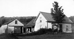
SARAH BUNKER HOUSE
195-322 December 3, 1799
Samuel Blake of Epsom, yeoman, to John Chesley of Epsom, blacksmith,
A piece of land in Epsom being a part of one of the home lots in said
town, to take its beginning at the northerly corner of the road leading
from the main road over Sanborn’s hill, then on the main road that
leads to Chichester to land of Amos Morrill, then southwesterly on the
said Morrill’s line 21 rods then easterly to the road leading over
Sanborn’s Hill, then northerly on said road to the first mentioned
bounds, to contain one acre and one half. – Samuel (his mark) Blake
(M) 78-476 March 27, 1845
Thomas D. Merrill of Epsom, to William Rand of Portsmouth, trader
A tract of land in Epsom bounded as follows: Beginning on the main road
leading through Epsom on the corner of land now occupied by George B.
Ham, 6 rods westerly of the corner bound of land occupied by Samuel Weeks,
thence running south 33 degrees west to land of George W. Batchelder,
thence north westerly by said Batchelder’s land to the road aforesaid
near the brook, thence easterly on the southerly side of said road to
the bound first name, to contain one and one fourth acre, together with
all the buildings thereon. – Thomas D. and Ann G. Merrill
(M) 112-522 June 16, 1852
John Chesley of Epsom to William Rand of Portsmouth,
A parcel of land in Epsom, beginning at the intersection of the main road
leading to Deerfield and the road leading to the hill road, so called,
near the brook and running sough 53 degrees east on the line of land now
belonging to said Rand 28 rods to the south west corner of land of Samuel
Weeks, thence west 12 rods and 18 links to a stone wall, thence by said
wall south 12 degrees west 10 rods and 10 links to the road leading to
the hill road, thence by said road north 13 degrees west 28 rods and 20
links to the bounds first mentioned containing about 2 acres be the same
more or less. John and Joann Chesley.
(M) 162-463 Sept. 29, 1860
John Chesley and wife to William Rand
(M) xxx-xxx date unknown
William Rand to Hall B. and Mary Rand
(M) 171-540
Hall B. Rand and Mary his wife to John D. Dow
(M) 185-293 June 20, 1866 (recopied
413-560)
John D. Dow and Lizzie E. Dow, wife of the said John D. Dow of Epsom to
Elbridge G. Batchelder,
Certain premises in Epsom beginning on the main road at the north westerly
corner of land occupied by Samuel Weeks and running thence westerly on
said main road 52 feet thence extending southerly ferrying the full width
of 52 feet to land of John Chesley and Uriah Hall Jr., being the same
premises conveyed by John Chesley and wife to William Rand, by deed dated
September 29, 1860 and recorded in the Merrimack Registry Lib. 162, Vol.
463 and by said William devised to said Hall B. and Mary Rand and conveyed
by the said Hall B. and Mary’s deed Merrimack Registry Lib. 171 Vol.
540 to me the said Dow. – John D. and Lizzie E. Dow
(M) 251-348 February 24, 1885
Daniel Yeaton of Epsom, administrator of the estate of Elbridge Batchelder,
late of Epsom, deceased, the Equity of Redemption and the Reversion of
the widow and minor children rights, to James Yeaton of Epsom,
All title of said deceased in a tract of land with the buildings thereon,
the same being the Equity of redemption and reversion of the widow and
minor children’s rights, containing about 22 acres bounded as follows:
buildings and lot lying on the south side of the highway leading from
Epsom Depot to Pleasant Pond and bounded north by said road, east by land
of the heirs of Samuel Weeks, south by land of John Chesley and west by
land of Mrs. Myra L. Ham – Field opposite containing about 12 acres
and pasture lying east of land of Josiah D. Langley containing about 10
acres. – Daniel Yeaton
(M) 271-3 February 24, 1885
James Yeaton of Epsom to Vianna R. Batchelder of Epsom,
All right and title I have in a tract of land with buildings thereon in
Epsom, on the south side of the highway leading from Epsom Depot to Pleasant
Pond and bounded north by said road, east by land belonging to heirs of
Samuel Weeks, south by land of John Chesley and west by land of Myra L.
Ham – Field lying on the opposite side of said road containing about
12 acres and pasture containing about 10 acres lying east of land of Josiah
D. Langley. – James Yeaton
(M) 339-570 July 5, 1901
Vienna R. Batchelder, George E. Batchelder, Nettie Batchelder, all of
Epsom and Edith G. Heath of Marlboro, MA to James V. Bunker of Epsom,
A parcel of land in Epsom with buildings thereon, bounded as follows:
beginning on the main road at the northwesterly corner of land formerly
occupied by Samuel Weeks and running thence westerly on said main road
52 feet, thence extending southerly carrying the full width of 52 feet
to land of D. G. and J. A. Chesley and land formerly owned by Uriah Hall
Jr., being the same premises conveyed by John Chesley and wife to William
Rand by deed dated Sept. 29, 1860 and recorded Merrimack Registry Lib.
162 Vol. 463 and by said William Rand devised to said Hall B. and Mary
Rand and conveyed by the said Hall B. and Mary Rand deed recorded Merrimack
Registry Lib. 171 Vol. 540 to me the said Dow – also some adjoining
land. – Vienna, George E. and Nettie Batchelder and Edith G. Heath.
(M) 553-503 Aug. 11, 1930
Sarah M. Bunker to Percy E. Hall, both of Epsom,
All the land and buildings except the barn, owned by me on the south side
of the Canterbury Road, so called, in Epsom, bounded as follows: On the
north by the highway leading from Knowles’ store to Center Hill,
known as the Canterbury Road, on the east by land of T.B. Langley, on
the south by land belonging to heirs of D.G. Chesley and on the west by
land of Grace B. Stone. The same containing one acre more or less. This
property being part of the estate of the late J. V. Bunker, being deeded
to him by the late Vienna Batchelder, July 5, 1901, recorded 339-570 and
passing to me at his death by will. The following reservations: all the
sawable wood and timber is reserved for one year, all vehicles, tools
and lumber in buildings owned by me, also the barn shall be allowed to
stand on the property until May 1, 1932. – Sarah M. Bunker
(M) 553-551 July 10, 1937
Percy E. Hall of Epsom to Wesley C. Couch of Epsom,
A tract of land with buildings thereon in Epsom bounded on the north by
the Epsom Center road, on the east by land of Wesley C. Couch, on the
south of land of Elenora C. Nutter on the west by land of Grace B. Stone,
containing 1 acre, being the property formerly owned by James N. Bunker.
– Percy E. and Lorretta R. Hall.
(M) 584-138 March 17, 1941
Wesley C. Couch of Alton to Robert H. and Elizabeth R. Whitaker of Concord,
A tract of land with the buildings thereon in Epsom bounded northerly
by the highway leading from Epsom Depot to the Center School House, southerly
by land of Elenora Nutter, easterly by the Chesley Road, so called, and
westerly by land of Grace B. Stone, about 9 acres, meaning the same premises
deeded to me in two deeds – one from Lilla Belle and N. William St.
Jean dated May 16, 1933 and deed of Percy E. Hall dated July 10, 1937.
Wesley C. and Mildred M. Couch
(M) 1359-524 October 18, 1979
Robert H. and Elizabeth R. Whitaker of Concord to James O. and M. Cyrene
Wells of Epsom,
A tract of land with the buildings thereon in Epsom bounded northerly
by the highway leading from Epsom Depot to the Center School House, southerly
by land of Elenora Nutter, easterly by the Chesley Road, so called, and
westerly by land of Grace B. Stone, about 9 acres, meaning the same premises
conveyed to us by Wesley C. Couch, March 17, 1941. – Robert H. and
Elizabeth R. Whitaker
STONE – KELLEY HOUSE
195-322 December 3, 1799
Samuel Blake of Epsom, yeoman, to John Chesley of Epsom, blacksmith,
A piece of land in Epsom being a part of one of the home lots in said
town, to take its beginning at the northerly corner of the road leading
from the main road over Sanborn’s hill, then on the main road that
leads to Chichester to land of Amos Morrill, then southwesterly on the
said Morrill’s line 21 rods then easterly to the road leading over
Sanborn’s Hill, then northerly on said road to the first mentioned
bounds, to contain on acre and one half. – Samuel (his mark) Blake
[Likely this property sold by Chesley and by about 1825, owned by Uriah Hall]
(M) 179-53 March 15, 1865 Mortgage
177-305 Warrantee
Uriah G. Hall to Elizabeth C. Libby of Epsom
Three acres land and buildings, corner of Sanborn Hill Road and Main road
through Epsom. – Uriah G. and Addie Hall
(M) 174-190 April 16, 1864
(NA)
Abigail Griffin, John Griffin, Sarah J. Griffin to George W. Ham
[George W. Ham married first Mary P. Marden and second, Myra L. Yeaton, who was married previously to Henry W. Sherburne. One son by this first marriage was Stillman E. Sherburne, who inherited the house and lot. Stillman married Clara Alton and had 3 children, of which daughter Grace, wife of Arthur Stone, later inherited the property; her mother Clara married second Edward M. Hall, and had one child with this marriage, Percy Edward Hall. Percy Hall owned the home next door.]
(M) 440-496 June 30, 1919
Harry E. Sherburne of Newport, Rhode Island, to Grace B. Stone of Epsom,
A tract of land with the buildings thereon in Epsom, bounded beginning
at the end of the new road (so called) leading from land now or formerly
of Daniel G. Chesley, to the main road so called, thence running easterly
by said main road to land now or formerly of Van Bunker; thence southerly
by said Bunker’s land to land now or formerly of Chesley brothers;
thence westerly by said Chesley brother’s land to the said new road,
thence northerly by said new road to the point first mentioned, to contain
3 acres more or less, and is the same obtained by the said grantor from
his grandmother Mrs. Elmira Ham by will about September 1886. – Harry
E. and Edythe M. Sherburne.
(M) 2245-717 February 26, 2001
Marian A. Huckins, un-remarried widow of Epsom to Elizabeth E. Kelley,
a single person,
A parcel of land in Epsom with the buildings thereon bounded at the end
of the new road, so called (Sanborn Hill Road) leading from land now or
formerly of Daniel G. Chesley, to the main road so called, thence running
easterly by said main road to land now or formerly of Van Bunker; thence
southerly by said Bunker’s land to land now or formerly of Chesley
brothers; thence westerly by said Chesley brother’s land to the said
new road, thence northerly by said new road to the point first mentioned,
to contain 3 acres more or less. Meaning to describe all the Grantor’s
interest in property in the deed of Harry E. Sherburne to Grace S. Stone,
June 30, 1919, and acquired title as heir at law of Grace S. Stone (a/k/a
Grace B. Stone), Merrimack County probate docket #77210. – Marian
A. Huckins.